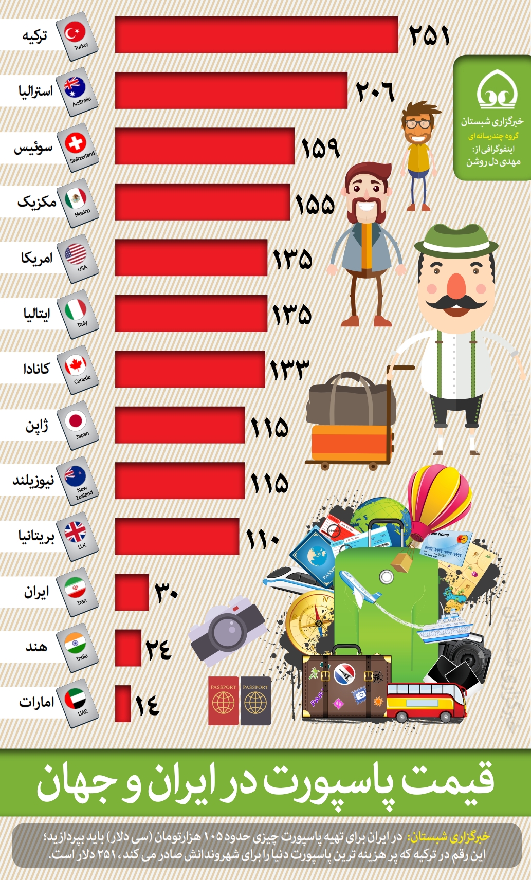
قیمت پاسپورت
توسط در تاریخ ۱۵ آذر ۱۳۹۵
توسط در تاریخ ۱۵ آذر ۱۳۹۵
توسط در تاریخ ۱۵ آذر ۱۳۹۵
توسط در تاریخ ۱۵ آذر ۱۳۹۵
توسط در تاریخ ۱۵ آذر ۱۳۹۵
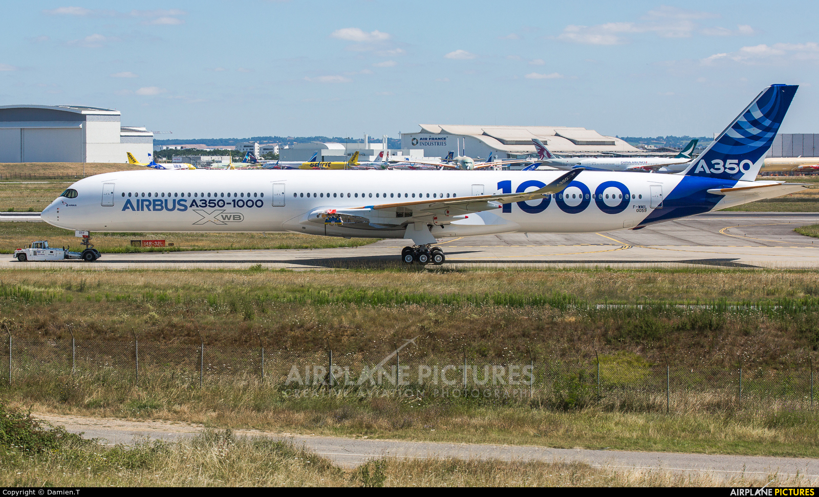
ایرباس ۳۵۰ سری هزار، که پیشرفتهترین مدل ایرباس محسوب میشود به تازگی به پراوز در آمده است این در حالی است که برخی از منابع خبری در ایران از احتمال تغییر سفارش ایران از مدل ۳۸۰ به این مدل خبر داده اند.
هواپیما A۳۵۰-۱۰۰۰ که به تازگی به پرواز در آمده است بزرگترین هواپیمای دو موتورهای است که ایرباس تاکنون تولید کرده است.
این هواپیما از پایگاه هوایی ایرباس در شهر تولوز در جنوب فرانسه به پرواز درآمد و پس از چند ساعت بر فراز جنوب فرانسه، به این پایگاه بازگشته است.
ایرباس A۳۵۰-۱۰۰۰ با برد ۱۵ هزار کیلومتری اش، امکان پرواز بدون توقف بین قاره ای را فراهم میکند.
موتورهای این هواپیما توسط شرکت رولزرویس تولید شده است. قرار است پس از یک سال آزمایش، خطوط هوایی قطر نخستین فروند از این هواپیما را سال آینده دریافت کند.
پروژه ایرباس A۳۵۰ از سال ۲۰۰۶ آغاز شده است. هواپیمای ۳۵۰ نخستین هواپیمای ایرباس است که در ساخت بدنهٔ آن بهجای آلیاژهای آلومینیوم سبک رایج در صعنت هواپیمایی، از پلیمر تقویت شده با فیبر کربن استفاده شده است.
این هواپیما برای رقابت با هواپیماهای بوئینگ ۷۷۷ و بوئینگ ۷۸۷ طراحی شده است و نخستین نمونه آن در سال ۲۰۱۳ میلادی به بازار آمده است.ایرباس A۳۵۰-۱۰۰۰ با هدف رقابت با بوئینگ ۷۷۷ ساخته شده و به گفته ایرباس، مصرف سوخت آن ۲۵ درصد کمتر است و ۳۰ تن وزن کمتری دارد.
پیش تر مدلهای سری ۸۰۰ و ۹۰۰ این هواپیما تولیدی شده بودند که رقیب اصلی بوئینگ ۷۸۷ هستند حالا با ورود ۳۵۰ سری هزار، این شرکت دوباره به نبرد با بوئینگ ۷۷۷ روی آورده است.
در گذشته ایرباس با مدل ۳۴۰ سری ۶۰۰ که چهار موتور پرمصرف داشت با بوئینگ ۷۷۷ که دو موتور پر قدرت دارد رقابت میکرد. اما ۳۴۰ به تازگی تولیدش متوقف شده است.
با توجه به گزارشهای فنی و مقایسههای مختلف، بوئینگ ۷۷۷ دارای مصرف سوخت و هزینه تعمیرات کمتری در مقابل ایرباس ۳۴۰ است. بیشتر خطوط پروازی جهان هم برای دوربردترین هواپیماهای خود از بوئینگ ۷۷۷ استفاده میکنند. بوئینگ ۷۷۷ برد پروازی تا ۱۷ هزار کیلومتر دارد. حالا ایرباس میخواهد با مدل ۳۵۰ سری هزار بازی را به نفع خود تغییر دهد.
قطر موتور یک هواپیمای ۷۷۷ به اندازه قطر یک هواپیمای بوئینگ ۷۳۷ است. موتور این هواپیما هم از قویترین موتورهای هواپیمای مسافربری در جهان محسوب میشود. این هواپیما در دو کلاس پروازی ظرفیت ۴۵۰ مسافر را دارد و قیمت آن حدود ۳۲۰ میلیون دلار است.
ایرانایر خواستار بهکارگیری بوئینگ ۷۷۷ است و در مذاکراتش با این شرکت خواستار خرید ۱۵ فروند بوئینگ ۷۷۷-۳۰۰ER و ۱۵ فروند ۷۷۷-۹ شده بود اما حالا با روی کار آمدن دولت جدید در ایالات متحده احتمال خرید این مدل بوئینگ کاهش یافته است.
از طرفی در ایران انتقاد به خرید ۱۲ فروند ایرباس ۳۸۰ که بزرگترین هواپیمای مسافر بری جهان است افزایش یافته، چرا که منتقدان معتقدند فرودگاهای کمی در ایران ظرفیت این هواپیما را دارند و بهتر است به جای خرید این هواپیما مدل کاربردیتری مانند ایرباس ۳۵۰ سری هزار به تعداد بیشتری خریداری شود شاید به همین دلیل باشد که خبرگزاری ایسنا از احتمال جایگزین شدن ایرباس ۳۵۰ به جای ۳۸۰ خبر داده است.
البته هم اکنون مدل ۳۲۱ ایرباس آماده تحویل به ایران است و پس از این مدل هم مدلهای ۳۳۰ تحویل ایران خواهد شد. ایران برای پروازهای دوربرد به مدل ۳۵۰ نیاز دارد البته فعلا معلوم نیست ایرباس ۳۵۰ سری هزار که توسط ایرانایر سفارش گذاری شده و احتمالا تقاضا برایش توسط ایران ایر هم افزایش خواهد یافت، چه زمانی به ایران تحویل داده خواهد شد.
ایرباس اعلام کرده است که از هم اکنون ۱۹۵ سفارش قطعی برای ۳۵۰ سری هزار دریافت کرده است و به این ترتیب امیدوار است طی سالهای آینده و با گسترش فروش سایر محصولاتش، سهم ۵۰ درصدی از بازار هواپیماهای پهنپیکر را بدست آورد.
در تفاهم نامه اولیه بین ایرباس و ایران ایر این شرکت ۱۶ فروند ایرباس ۳۵۰ سفارش داده است. اگر ۱۲ فروند ایرباس ۳۸۰ با این مدل تعویض شود سفارش ایران به ۲۸ فروند خواهد رسید. شرکت ایرباس مدعی است که مصرف سوخت این هواپیما و هزینههای عملیاتی آن به مراتب کمتر از بوئینگ ۷۸۷ است.
این مدل در سه سری ۸۰۰، ۹۰۰ و ۱۰۰۰ به ترتیب در دو کلاس پروازی میتواند ۲۷۶، ۳۱۵ و ۳۸۷ مسافر را جابهجا کند و به این ترتیب ۲۶۹، ۳۰۴ و ۳۵۱ میلیون دلار قیمت و تا ۱۵ هزار کیلومتر، برد پروازی دارد.
مدل سری ۸۰۰ ایرباس ۳۵۰ حدود ۶۰ متر، سری ۹۰۰ حدود ۶۶ متر و سری هزار حدود ۷۳ متر طول دارد. ایرباس در مجموع برای هر سه مدل از ۳۵۰ تا کنون بیش از ۸۰۰ سفارش خرید دریافت کرده است. البته به دلیل تکنولوژی بالا ایرباس از برنامه تولید این هواپیما بسیار عقب است. فعلا شرکت قطر ایر با ۸۰ ، امارات با ۷۰ و سنگاپور ایر با ۷۰، سه مشتری اصلی این هواپیما هستند.
اگر سفارش ایران به ۲۸ فروند برسد ایران ایر جزو ۲۰ شرکت هوایی جهان از نظر تعداد است که خواستار خرید این هواپیما است. خرید این مدل با این تعداد میتواند روح تازه ای را در بدنه بیجان شرکت ایران ایر بدمد و ایران را برای رقابت با شرکتهای هوایی در خاورمیانه امیدوار کند.
در حال حاضر ایرانیان سالانه بیش از سه میلیارد دلار برای خرید بلیط هواپیما از شرکتهای هوایی خارجی مانند قطر و امارات هزینه میکنند.
توسط در تاریخ ۱۵ آذر ۱۳۹۵
در حکمی از سوی مدیر کل میراث فرهنگی، صنایع دستی و گردشگری خراسان رضوی مجید مذهبی به عنوان دبیر کمیته طبیعت گردی خراسان رضوی معرفی شد.
به گزارش روابط عمومی اداره کل میراث فرهنگی خراسان رضوی، مجید مذهبی اظهارداشت: آنچه قرار است در استان در بحث گردشگری اتفاق بیفتد ساماندهی و سازمان دهی حوزه طبیعت گردی است چرا که به نفع همه سازمان های درگیر طبیعت گردی است.
وی افزود: با ایجاد کمیته طبیعت گردی در اداره کل میراث فرهنگی خراسان رضوی مشکلات ساختاری مرتفع خواهد شد در حال حاضر مشکلات زیادی در بحث ساماندهی گروه های طبیعتگردی و گوهنوردی داریم.
مذهبی تصریح کرد: باید خط قرمز های این حوزه را شناسایی و معرفی کنیم.، متاسفانه بحث طبیعت گردی در کشور مغفول مانده است.
دبیر کمیته طبیعت گردی خراسان رضوی عنوان کرد: امروز سازمان های مختلفی در حوزه طبیعت گردی ورود پیدا کرده اند و از ظن خود یار ما شده اند اما این تداخل و موازی کاری مشکلات ، حواشی وحوادث اجتماعی زیادی را به وجود آورده است و از طرفی عدم هماهنگی سازمان های متولی و هم افزایی با مردم و سازمانهای مردم نهاد وNGOها نیز سبب سرگردانی همه شده است.
وی بیان کرد: امیدواریم با تشکیل کمیته طبیعت گردی بتوانیم پلی شویم بین قوانین و مقررات، مردم و NGOها البته مهم تر از بحث ساماندهی ،توجه به سازماندهی است که ساختار را تعریف میکند.
مذهبی خاطرنشان کرد: طبیعت گردی بخشی از گردشگری است و متولی ان اداره کل میراثفرهنگی صنایع دستی و گردشگری است و کمیته ساماندهی و سازماندهی طبیعت گردی در خراسان رضوی به اداره کل میراث فرهنگی خراسان رضوی واگذار شده است.
توسط در تاریخ ۱۵ آذر ۱۳۹۵
معاون میراث فرهنگی اداره کل میراث فرهنگی زنجان گفت: تنها آسیاب آبی فعال استان زنجان در روستای دهشیر واجد ارزش ثبت ملی شناخته شد.
به گزارش اداره کل میراث فرهنگی، صنایع دستی و گردشگری زنجان، مهرداد عسگریان ادامه داد: آسیاب آبی روستای دهشیر در میان باغات و مزارع شمال غرب روستا و در فاصله حدود 100متری از خانه هـای روستا قرار دارد. از سمت شرق نیز با فاصله اندکی به رودخانه دهشیر میرسد.
وی افزود: آسیاب دهشیر در اصل متعلق به پـدربزرگ مالـک بـوده کـه در زمـان قاجاریـه زنـدگی میکرده است.
عسگریان در خصوص بنای این آسیاب گفت: ساختمان آسیاب بنای بسیار ساده روستایی با مصالح بوم آورد است که احتمالا از دوره قاجار و یا حتی قبل از آن تا به امروز به عنوان آسیاب کارکرد داشته است. آنچه که موجب اهمیت این اثر شده کارکرد آن به عنوان یک آسیاب آبی فعال است.
به گفته معاون میراث فرهنگی اداره کل میراث فرهنگی، صنایع دستی و گردشگری زنجان، مـردم روسـتا نیز وجـود آسـیاب از گذشته های دور را در این مکان تایید می نمایند و مردم محلی به آسیاب دهشیر "دِرمـان" مـیگوینـد کـه در زبـان ترکی به معنی آسیاب است.
معاون میراث فرهنگی اداره کل میراث فرهنگی در خصوص ویژگی های این اثر اظهارداشت: در گذشته به دلیل فراوانی منابع آبهای سطحی در زنجان در بسیاری از مناطق شهری و روستایی این استان آسیابهای آبی زیادی وجود داشت که هم اکنون به صورت محوطه قدیمی است اما آسیاب آبی دهشیر تنها آسیاب آبی فعال در استان زنجان است که خوشبختانه مالک آن خواستار ادامه فعالیت سنتی است.
توسط در تاریخ ۱۵ آذر ۱۳۹۵
تهران 15 آذر 1395 (مرکز اطلاعات سازمان ملل متحد) – دبیر کل سازمان ملل متحد در پیامی به مناسبت روز جهانی خاک، 5 دسامبر2016 برابر با 15 آذرماه جاری خواستار توجه بیشتر به موضوعات مهمی که خاک را تحت تاثیر قرار می دهند، شامل تغییر اقلیمی، مقاومت ضد میکروبی، بیماری هایی که منشاءخاک دارند، آلودگی و تغذیه شد.
متن کامل پیام بان کی مون به شرح زیر است:
در جهان کنونی که جمعیت در حال رشد، شهرها در حال گسترش و اقلیم در حال تغییربوده وغذای بیشتری مورد نیاز است، مصرانه برای تضمین ارائه خدمات ضروری به خاک سالم نیاز داریم .
نظام ها و رویه های مدیریت پایدار، توانایی کامل خاک را برای حمایت از تولید غذا، ذخیره و تامین آب پاکیزه، حفظ تنوع زیستی، جذب کربن بیشتر و افزایش تاب آوری تغییرات اقلیمی میسر می سازد.
مدیریت پایدار خاک هم چنین باعث پیشرفت دستور کار 2030 برای توسعه پایدار و موافقت نامه پاریس در خصوص تغییرات اقلیمی می شود. این موضوع باید تبدیل به هنجار جهانی گردد تا استفاده از خاک در حال حاضر را بهینه سازد و از آن در مدت زمان طولانی حافظت و نگهداری نماید.
حبوبات که به عنوان بنشن نیز شناخته می شوند، می توانند سلامت خاک را افزایش دهند در حالی که از رژیم غذایی سالم تر و مغذی تری حمایت می کنند. لوبیای خشک، نخود فرنگی، عدس و سایر حبوبات با هم زیستی بی نظیری با خاک ترکیب می شوند که از محیط زیست حمایت می کند، بهره وری را افزایش می دهد، به انطباق با تغییرات اقلیمی کمک می نماید و مواد مغذی لازم برای خاک و محصولات بعدی را فراهم می آورد. حبوبات می توانند نیتروژن جو را در ریشه های خود تثبیت کنند. حبوبات هم چنین با آزاد سازی فسفر موجود در خاک که آن را برای سایر گیاهان قابل دسترسی و استفاده می نماید، نیاز به استفاده از کود شیمیایی اضافی را کاهش می دهند. تمامی این موارد از محرک های توسعه پایدار هستند.
جامعه بین المللی روش های هماهنگ و مشارکتی برای حفاظت و مدیریت پایدار خاک شناسایی کرده است. توصیه های ارزشمندی در "راهنمای داوطلبانه برای مدیریت پایدار خاک" وجود دارد که توسط "مشارکت جهانی خاک" تهیه و اخیر نیز مورد تایید واقع شده است. پیروی از این راهنمایی ها به هموار ساختن مسیر برای افزایش سلامت خاک کمک کرده و و توانایی آن را برای حمایت از اقدامات کاهشی و سازگار کننده در آب و هوای در حال تغییر می گشاید.
در روز جهانی خاک، اینجانب خواستار توجه بیشتر به موضوعات مهمی که خاک را تحت تاثیر قرار می دهند، شامل تغییر اقلیمی، مقاومت ضد میکروبی، بیماری هایی که منشاءخاک دارند، آلودگی، تغذیه و سلامت انسان هستم.
بیایید بر اساس سال جهانی خاک 2015، سال جهانی حبوبات 2016 و تمامی فعالیت های حامی مدیریت پایدار خاک، هکتارهای بیشتری از خاک سالم را در همه جا ایجاد نماییم.
توسط در تاریخ ۱۵ آذر ۱۳۹۵